A pilot study aimed at the establishment of Marine Protected Areas
in the Maltese islands
Konrad Pirotta & Patrick J. Schembri
Marine Ecology Research Group,
Department of Biology,
University of Malta,
Msida MSD06,
Malta
(contact: Prof. Patrick J. Schembri, e-mail: patrick.j.schembri@um.edu.mt)
 |
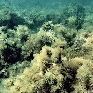
'Forests' of photophilic algae growing on bedrock
and boulders in shallow water (3m). The dominant species in this
image are Cystoseira
ercegovicii, Padina pavonica, Dictyota linearis
and Sargassum vulgare, but
many different assemblages dominated by other species occur in the
study area.
The Maltese Islands at the centre of the Mediterranean have a
coastline of ca 190km and a submerged area (to a depth of 100m) of
approximately 1,940kmē. They are densely populated and are now visited
by over a million tourists every year. Human pressure on the environment
has increased tremendously over the past four decades and today, no part
of the local environment is totally free from the effects of human
activities. At sea, although difficult to ascertain the extent of human
impact, one can claim with an appreciable degree of certainty that
divers have probably trekked the entire seabed from the mean sea level
to a depth about 65m, while bottom trawling dumping of dredge spoil,
major coastal projects and day-to-day uses of coastal resources and
those of the sea adjacent to the coast have all had their toll. Although
protection of the coastal sea may be largely seen as a domestic issue,
conservation of the marine environment at large is now an international
dimension; this is especially true for the Mediterranean region where
regional agreements concerning marine protection have existed since 1975
in the form of the Mediterranean Action Plan (MAP) adopted by the
Mediterranean countries and the (then) EEC, followed by the Barcelona
Convention in 1976, administered by the United Nations Environment
Programme (UNEP).
In the past decade, a number of the pilot projects implemented under
the aegis of the Barcelona Convention and its protocols and related to
the conservation and rational use of the coastal zone, have been brought
together and regulated under the Coastal Area Management Programmes
(CAMPs). In December of 1999 an agreement to implement a Coastal Area
Management Programmes in Malta (CAMP-Malta) was signed between the
Government of Malta and UNEP. One thematic activity within this
programme was the study of an 11km stretch of coastline on the
northwestern coast of the island of Malta, and of the sea area off it to
the 50m depth contour, covering 4.75 km2 of seabed, with the aim to
evaluate it for eventual designation as a Marine Protected Area (MPA)
and to generate information upon which to base a management plan for the
area. This area, known as Rdum Majjiesa, was selected as it is
representative of the coastal and marine habitats present in the Maltese
Islands and it is relatively unaffected by human activities. Considering
that at present there are no MPAs within Maltese territory, the
importance of this pilot project is self-evident.
The primary objective of this study was the assessment of the
biological characteristics of the proposed site. This assessment was
intended to produce an inventory of the major biological complexes
occurring within the site's boundaries, and to generate base maps for
the use of environmental managers to draw plans for zoning, managing and
protecting the site. Extensive benthic and bathymetric surveys of the
study area yielded considerable data, including detailed maps (at a
scale of 1:2500) of the bathymetry, submarine geophysical features,
seascapes and benthic biotic assemblages of the area. As a result of
these studies we are now able to make a strong case for the designation
of this site as Malta's first MPA.
The most outstanding physical feature of the study area is the
heterogeneity of the seabed geomorphology (seascape) and the bottom
types present. The site consists essentially of the two rocky shoals
extending about 1km from the shore, generated from wave-cut
shore-platform terraces. The seaward boundary of these shoals consists
of stepped drop-offs or steep slopes. Collapse under gravity of blocks
from the edges of the backing limestone escarpments on the terrestrial
part of the area have resulted in aggregations of boulders along much of
the coast; these boulders extend out to sea as submarine boulder fields
at several locations. Bays with sandy pocket-beaches and coves are also
present in the area, formed at the seaward extremities of major fault
systems that cross the island. The southern sector of the study area (an
area known as Ras ir-Raheb) consists of vertical sea cliffs extending
for about 1.9km of coastline and which give rise to continuous drop-offs
below sea level; semi-submerged caves are also present in this sector.
Given the heterogeneous nature of the seabed it is hardly surprising
that the area is characterised by an equally diverse and rich biota.
Five main biotic assemblages are represented in the study area: those of
hard beds and rocks, seagrass meadows and fine sands cover large areas
of seabed, while those of coarse sand and stones and pebbles are more
sparsely represented. Pockets of maerl are also present.
 |
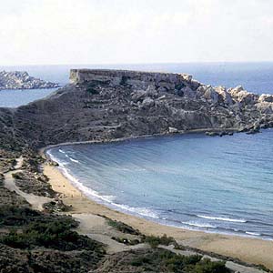
The Ras il-Qarraba promontory one of the most
conspicuous features in the study area. Note the boulder screes that
extend underwater as a boulder fields and the bays with pocket sandy
beaches and seagrass meadows offshore.
Neptune Grass, Posidonia oceanica, dominates large areas of the
seabed. Extensive meadows occur on sand as well as on bedrock overlain
by a veneer of sediment. From north to south, the meadows are
practically continuous although showing different bed morphologies (so
called 'ecomophoses') in different places. Although Posidonia
efficiently colonises both hard and soft substrata, on sand it generates
thick layers of matte, which, when extensive, develop an organic
substratum that is colonised by a wide variety of photophilic and
sciaphilic algae growing among the Posidonia shoots. Thick matte also
produces matte walls at the edges of the meadow. In places, these walls
may be over 2m high. A large variety of organisms occur within the
Posidonia meadows, including some of conservation interest such as the
bivalve Pinna nobilis (Noble Pen-shell), a regionally and locally
protected species.
The Lesser Neptune Grass, Cymodocea nodosa, is also very
abundant in the study area where it occurs on sand and precedes and
succeeds Posidonia oceanica. This seagrass forms a major
association within the biocoenosis of fine sands. The Cymodocea
beds are susceptible to extensive damage by strong waves due to their
open morphology. Cymodocea meadows recorded during this study are
some of the most extensive meadows known to-date from the Maltese
Islands.
Excluding bedrock colonised by Posidonia oceanica, hard
substrata are almost completely dominated by photophilic algae.
Phaeophytes are by far the most abundant macroalgae, and Cystoseira
spinosa var. tenuior is the commonest and most conspicuous
species. It occurs over large areas both as almost monospecific stands
(in the sense that it is not accompanied by any other tall-growing,
canopy-forming algae) and also accompanied by other sub-dominant or
co-dominant species. At depths greater than 13-15m, hard beds and rocks
other photophilic and/or sciaphilic (if the light intensity is reduced)
algae become dominant. Tall-growing species dominating these deeper
water associations include Dictyopteris polypodioides, Cystoseira
squarrosa, Sargassum vulgare and Sargassum acinarium.
Hard substrata occurring in deeper waters include drop-offs.
Sciaphilic assemblages characterise these habitats and Flabellia petiolata,
Halimeda tuna and Peyssonnelia sp. are the most
abundant dominants in these assemblages throughout the study area. Other
rhodophytes such as Jania sp., a number of calcareous algae
(mostly corallines), and low-growing hydroids may at times be very
abundant as well, but are not conspicuous as they are overshadowed by
the larger and more noticeable species. The same applies for a number of
low-growing algae that occur as an 'undergrowth' beneath the other
tall-growing species, where they may become covered with silt and form
an algal turf. Two such examples are Dasycladus vermicularis
and Vidalia volubilis.
Given the heterogeneity of the study area and the diversity (and
social and economic significance) of human activities occurring within
it, applying the Multiple Use Marine Protected Area model seems to be
the most realistic and appropriate approach to protect and manage this
region. Adopting this model would allow the preservation and maintenance
of biodiversity and the conservation of seascapes and adjacent
landscapes on one hand, and the fulfilment of social and economic
requirements and obligations on the other. One fundamental requirement
of a Multiple Use Marine Protected Area is a management program based on
a multi-level protection system in which different regions within the
same MPA are managed with regulations and prohibition of activities that
vary from one region to another. Management plans must also include
monitoring programs.
The CAMP-Malta study, including our results and proposals for
designation of our study area as a MPA and for its management and
monitoring, have been submitted to the Government of Malta by UNEP and
are currently being considered. Designation of this area as a MPA would
signify formal acknowledgement of the special value of these waters and
may discourage excessive new development and focus attention on the
natural resources of the area. It would also act as a pilot for
assessing the benefits of MPAs in the Maltese context, as a resource for
marine research, and for refining environmental policies. The Rdum
Majjiesa area has been proposed by our group to the MARS network as a
European Marine Biodiversity Focal Site (EMBiF) while UNEP-MAP is
funding additional work on this area, mainly the formulation of a
management plan, under its Med-MPA programme.
|
